


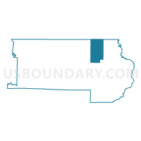
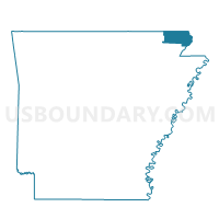
Pollard Voting District, Clay County, Arkansas
About
Outline

Summary
| Unique Area Identifier | 526125 |
| Name | Pollard Voting District |
| County | Clay County |
| State | Arkansas |
| Area (square miles) | 28.99 |
| Land Area (square miles) | 28.92 |
| Water Area (square miles) | 0.07 |
| % of Land Area | 99.76 |
| % of Water Area | 0.24 |
| Latitude of the Internal Point | 36.43984820 |
| Longtitude of the Internal Point | -90.28228690 |
Maps

Graphs
Select a template below for downloading or customizing gragh for Pollard Voting District, Clay County, Arkansas


Neighbors
Neighoring Voting District (by Name) Neighboring Voting District on the Map
- Bennett & Lemmons Voting District, Clay County, AR
- Bradshaw & Haywood Voting District, Clay County, AR
- Chalk Bluff & Liddell Voting District, Clay County, AR
- Fagus Voting District, Butler County, MO
- North St. Francis Voting District, Clay County, AR
- Oglesville Voting District, Butler County, MO
Top 10 Neighboring County Subdivision (by Population) Neighboring County Subdivision on the Map
- North St. Francis township, Clay County, AR (2,628)
- Gillis Bluff township, Butler County, MO (683)
- Bradshaw-Haywood township, Clay County, AR (645)
- Bennett-Lemmons township, Clay County, AR (643)
- Chalk Bluff-Liddell township, Clay County, AR (598)
- Pollard township, Clay County, AR (532)
Top 10 Neighboring Place (by Population) Neighboring Place on the Map
Top 10 Neighboring Unified School District (by Population) Neighboring Unified School District on the Map
- Twin Rivers R-X School District, MO (5,956)
- Piggott School District, AR (5,835)
- Rector School District, AR (4,020)
Top 10 Neighboring State Legislative District Lower Chamber (by Population) Neighboring State Legislative District Lower Chamber on the Map
Top 10 Neighboring State Legislative District Upper Chamber (by Population) Neighboring State Legislative District Upper Chamber on the Map
Top 10 Neighboring 111th Congressional District (by Population) Neighboring 111th Congressional District on the Map
Top 10 Neighboring Census Tract (by Population) Neighboring Census Tract on the Map
- Census Tract 9506, Butler County, MO (4,287)
- Census Tract 9506, Clay County, AR (3,934)
- Census Tract 9502, Clay County, AR (2,304)
- Census Tract 9501, Clay County, AR (2,111)